Google key:
This is an optional parameter.
All Maps API applications should load the Maps API using an API key. Using an API key enables you to monitor your application's Maps API usage, and ensures that Google can contact you about your application if necessary.
To get a valid Google Key
Sign up for the Google Maps APIThis value can be dynamic so you can put this value in a Db table
Map container:
The page element where insert the Google map.
The element must have the ID attribute
Marker event open:
The mouse event, click or mouseover, that open the info window
Marker animation:
BOUNCE
Marker bounces
DROP
Marker falls from the top of the map ending with a small bounce.
Default view:
The defalt rendered view between: Normal and Satellite
Marker cursor:
The mouse cursor show when the user pass the mouse over the marker
Background color:
Color used for the background of the Map div. This color will be visible when tiles have not yet loaded as the user pans.
Pan markers:
Pans the map by the minimum amount necessary to contain the given markers.
Center address:
Center the map on the defined address, must be according with Goolge map address definition
Center map:
Latitude/Longitude:
The initial Map center latitude and longitude
User location:
If checked the extension try to center the map on the user geolocation, if the browser support it an the user must allow the browser to geolocation it's position
Resizable map:
If checked the map container can be resized with mouse drag. And yoiu can setup the minimum and maximum resize dimensions
Map type:
Insert the buttons that let the user toggle between map types (such as Map and Satellite)
Map type position:
Identifiers used to specify the placement of controls on the map. Controls are positioned relative to other controls in the same layout position. Controls that are added first are positioned closer to the edge of the map.
Zoom Default
The default zoom control. The control which DEFAULT maps to will vary according to map size and other factors. It may change in future versions of the API.
Zoom Small
A small control with buttons to zoom in and out.
Zoom Large
The larger control, with the zoom slider in addition to +/- buttons
Zoom level:
The initial Map zoom level
Zoom position:
Define if not show the control (choose None) or specify the placement of controls on the map. Controls are positioned relative to other controls in the same layout position. Controls that are added first are positioned closer to the edge of the map.
Scale position:
Define if not show the control (choose None) or specify the placement of controls on the map. Controls are positioned relative to other controls in the same layout position. Controls that are added first are positioned closer to the edge of the map.
Pan position:
Define if not show the control (choose None) or specify the placement of controls on the map. Controls are positioned relative to other controls in the same layout position. Controls that are added first are positioned closer to the edge of the map.
Rotate position:
Define if not show the control (choose None) or specify the placement of controls on the map. Controls are positioned relative to other controls in the same layout position. Controls that are added first are positioned closer to the edge of the map.
Street view position:
Define if not show the control (choose None) or specify the placement of controls on the map. Controls are positioned relative to other controls in the same layout position. Controls that are added first are positioned closer to the edge of the map.
Overview:
Insert a collapsible overview map in the corner of the screen. You cxan choose if the default is open or close
Layer traffic:
Show the traffic layer
Layer transit:
Show the transit layer
Layer bicycling:
Show the bicycling layer
Layer cloud:
A layer showing cloud imagery
Layer panoramio:
A PanoramioLayer displays photos from Panoramio as a rendered layer.
Layer weather:
A layer that displays weather icons.
Weather speed unit:
The wind speed unit displayed by the weather layer
between Kilometers per hours - meters per hour and miles per hour
Weather temp. unit:
The temperature unit displayed by the weather layer, between celsius and fahrenheit
Weather color:
The color of the labels displayed on the weather layer
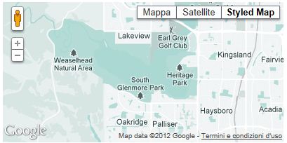
Map style title:
If you define a StyledMapTitle and applying it to the map this creates a new map type, which can be selected from the map type control.
Like:

Map style:
Styled maps allow you to customize the presentation of the standard Google base maps, changing the visual display of such elements as roads, parks, and built-up areas.
Creating styles by hand and testing your code to see how they look is potentially time-consuming. Instead, you can use the
Styled Map Wizard to set up the JSON for your map's styles. The wizard allows you to select features and their elements, apply operations to those features, and save the styles to JSON, which you can copy and paste into your application. We create a new version of the Google wizard where you can load an exixting map style.
Custon styled map wizard
Map style buttons:


With this 2 buttons you can call our custom Styled Map Wizard where is possible load an existant map style. The button

send the current style you have in extension panel to our custonìm wizard and preload it in the wizard. IOn our custom wizard there is a "Copy to clipboard" button that copy the modified style in the pc clipboard and with the

you can paste the new style directly in the extension panel

